This Is Not Good
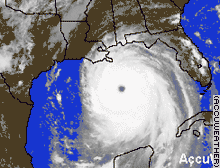
Hurricane Katrina, now a Category 5 storm, is barreling straight for New Orleans. This is particularly bad for the 'Big Easy' because about 70% of New Orleans is below sea level, and the storm surge is expected to overwhelm the levees that surround New Orleans, which at their highest are 18 feet. The storm surge is expected to be 28 feet. In a statement from the National Weather Service in Slidell, near New Orleans, Louisiana and I quote "warned that much of the affected area "will be uninhabitable for weeks, perhaps longer."Low-rise, wood-frame buildings will be destroyed, and concrete apartment buildings 'will sustain major damage,' it said." "'High-rise office and apartment buildings will sway dangerously, a few to the point of total collapse,' the warning read." "All windows will blow out. Airborne debris will be widespread, and may include heavy items such as household appliances and even light vehicles." As of 8 PM ET Sunday, the storm was 130 miles south of the mouth of the Mississippi River, and the top sustained winds of 160 mph. I'm going to keep watching this on and off and I'll post if anything interesting comes up. One last thing, the storm is expected to make landfall in the next 12 hours. Below is an animated satellite image showing the movement of Hurricane Katrina courtesy of Accuweather.
posted by A. Surasky at 6:03 PM
![]()


0 Comments:
Post a Comment
<< Home